HOME
> Useful Information > Korea in Brief > Location
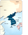
Korea lies adjacent to China and Japan. The northern
border of Korea is formed by the Amnokgang (Yalu) and
Dumangang (Tumen) rivers, which separate it from Manchuria.
A 16-kilometer segment of the Dumangang to the east also
serves as a natural border with Russia.
Two hundred kilometers separate the peninsula from eastern
China. The shortest distance between Korean and Chinese
coasts is 200 kilometers and from the southeastern tip
of the peninsula, the nearest point on the Japanese coast
is also about 200 kilometers away.
The Korean Peninsula extends about 1,000 kilometers
southward from the northeast Asian continental landmass.
Roughly 300 kilometers in width, climate variations are
more pronounced along the south-north axis. Differences
in plant vegetation can be seen between the colder north
and the warmer south.
The peninsula and all of its associated islands lie between
33o06'40"N and 43o00'39"N parallels and 124o11'00"E
and 131o52'08"E meridians. The latitudinal location
of Korea is similar to that of the Iberian Peninsula and
Greece. The entire peninsula corresponds approximately
to the north-south span of the state of California.
Extreme points
Places
Coordinates
Northernmost
Yeopojin, Hamgyeongbuk-do
43o00'39"N
Southernmost
Marado Island, Jeju-do
33o06'40"N
Easternmost
Dokdo Island, Gyeongsangbuk-do
131o52'08"E
Westernmost
Maando Island, Pyeonganbuk-do
124o11'00"E
Longitudinally, Korea lies straight north of the Philippines
and central Australia. The meridian of 127o30'E passes
through the middle of the Korean Peninsula. Korea, however,
shares the same standard meridian of 135oE with Japan.
Seoul and Tokyo local time is nine hours earlier than
Greenwich Mean Time (GMT).
Territory
The total area of the peninsula, including its islands,
is 222,154 square kilometers of which about 45 percent
(99,313 square kilometers), excluding the area in the
Demilitarized Zone (DMZ), constitutes the territory of
South Korea. The combined territories of South and North
Korea are similar to the size of Britain (244,100 square
kilometers) and Guyana (215,000 square kilometers). South
Korea alone is about the size of Hungary (93,000 square
kilometers) and Jordan (97,700 square kilometers).
There are about 3,000 islands belonging to Korea. The
islands are located mostly off the west and south coasts;
only a handful of them lie off the East Sea. Ulleungdo,
the largest island in the East Sea, serves as a major
fishery base as does Dokdo. Bigger islands include Jejudo
- the largest, Geojedo, Ganghwado, and Namhaedo.
At the end of World War II, the peninsula was divided
into a northern zone occupied by Soviet forces and a southern
zone occupied by U.S. forces. The boundary between the
two zones was the 38th parallel. In 1953, at the end of
the Korean War, a new border was fixed at the Demilitarized
Zone (DMZ), a 4 kilometer-wide strip of land that runs
along the lines of ceasefire from the east to the west
coast for a distance of about 241 kilometers.
Geographical Regions
Mountain ranges have traditionally served as natural boundary
markers between regions. Because these natural boundaries
inhibited contacts between peoples living on either side
of the range, subtle, and sometimes substantial, regional
differences developed in both the spoken language and
customs of the people. These regional distinctions also
correspond to the traditional administrative divisions
set up during the Joseon Dynasty (1392-1910).
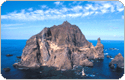
Dokdo
Island
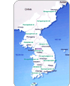
The Korean Peninsula is divided into three distinct
regions; Central, South and North. These macro regions
are divided into three separate geographical spheres,
each of which shows particular economic, cultural and
physical distinctiveness. In the Central region are the
Seoul metropolitan area, Chungcheong and Gangwon provinces;
in the South, Gyeongsang, Jeolla and Jeju provinces; and
in the North, Pyeongan, Hamgyeong and Hwanghae provinces.
The term "northern area" traditionally referred
to those regions of Pyeongan and Hamgyeong provinces prior
to the division of the peninsula in 1945. The "North"
now refers to all the areas north of the Demilitarized
Zone, comprising Pyeongan, Hamgyeong, Hwanghae and the
northern parts of the Gyeonggi and Gangwon provinces.
The Central Region
This region consists of the Seoul metropolitan area which
is part of, Gyeonggi Province, Chungcheong Province to
the south, and Gangwon province to the east.
The Capital (Seoul / Gyeonggi) Area : This includes
Seoul and Incheon, which encompass the Gyeonggi-do. The
capital area, as the name implies, is the center of all
political, economic and cultural activity in South Korea.
Clustered around Seoul are also a number of smaller cities,
which form a continuous and sprawling urban area. In and
around Seoul is the largest concentration of the nation's
industries. As the hub of South Korea's transportation
networks, with Gimpo International Airport located on
the western outskirts of Seoul, the newly built Incheon
International Airport, and railroad networks that connect
to all parts of the country, the capital area serves as
South Korea's gateway to the world. Given its strategic
importance, the dialect spoken in Seoul is considered
to be the nation's standard language.
Chungcheong Province : This region lies between
the capital area and the South. Cheongju and Daejeon are
the leading urban centers of the region, respectively.
Lying just below the capital area, this region consisting
of Chungcheongnam-do and Chungcheongbuk-do, has been characterized
as a southern extension of Seoul; its proximity to the
capital has been economically advantageous. New industries
have recently mushroomed along the Asanman Bay on the
west coast. The region has also profited from transportation
and urban services available for Seoul and its vicinity.
Chungcheong and Gyeonggi provinces specialize in horticulture
and dairy farming to meet the huge demands of the nearby
urban centers of the capital area.
Gangwon Province : This region lies to the east
of the capital area. The Taebaeksan Mountain range, which
runs north-south through the middle of the region, divides
the province into eastern coastal and western inland areas.
Gangneung, Chuncheon, and Wonju are its leading urban
areas. Gangwon-do offers a variety of opportunities for
tourism and sports, with its rugged terrain. Mining industries,
once a major sector in the regional economy, have recently
experienced a drastic decline due to competition from
cheaper foreign-imported coal and minerals. The fall of
mining industries, coupled with the national trend of
rural to urban migration, are the major contributing factors
for the recent migration out of the region. Gangwon-do,
with less than 2 million residents, has now the smallest
population of all the mainland provinces.
The South Region
The region includes the Gyeongsang Province, located in
the southeast, Jeolla Province in the southwest, and Jejudo
province which lies off the south coast.
Gyeongsang Province : This area includes metropolitan
cities Busan, Daegu, and Ulsan encompassing Gyeongsangbuk-do
and Gyeongsangnam-do. Busan and Daegu are the major urban
centers of the province, being the second (4 million)
and third (2.5 million) largest cities in South Korea.
This region is characterized by the vast basin of the
Nakdonggang River and is surrounded by the Sobaeksan mountain
ranges. Due to the rugged topography of the surrounding
mountains, sub-areas within the region share common cultural
traits such as dialect and custom, which are quite distinct
from peoples of other regions. The fact that Gyeongsang
Province also has another name, "Yeongnam,"
which literally means "south of the mountain pass,"
attests to the key role that the mountains have historically
played in fostering regional differences between the Korean
people.
Gyeongsang Province has one of the largest industrial
agglomerations, second only to the capital area, due mainly
to the heavy investments in the region by the South Korean
government since the 1960s. These heavy industrial facilities
of steel, shipbuilding, automobile and petrochemical factories
are largely concentrated along the southeast stretch of
Pohang, through Ulsan, Busan, Changwon, and Masan. The
northern part also has two major clusters of industries
around Daegu and Gumi, specializing in textile and electronics.
Jeolla Province : Jeolla Province is located southwest
of the peninsula and comprises of Jeollabuk-do and Jeollanam-do.
Gwangju, Jeonju, and Naju are their respective centers.
Honam" is another name for Jeolla Province. The flat
fertile lands of the Geumgang and Yeongsangang river basins,
as well as the coastal lowlands, have made the region
the major granary of the nation. The regional economy
has lagged somewhat behind the capital and Gyeongsang
regions due to sparse industrial investments made there
during the past decades. However, this situation is changing
and the region is now experiencing industrial growth in
major urban centers like Gwangju and Jeonju, as well as
along its western coast. Also, the tidal flats near Gunsan
and Mokpo have recently been reclaimed, adding new land
for industrial development.
Jejudo Island : Jejudo is the largest Island in
Korea located about 140 kilometers south of Mokpo in the
South Sea. Its historic isolation from the mainland contributed
to the Jejudo peoples' distinct dialect and lifestyle.
Of volcanic origin, the island has rugged topography of
numerous hills, gorges, and waterfalls. Because of its
subtropical climate and the unique lifestyles and customs
of its people, tourism is the region's most important
industry. The island is also famous for its subtropical
fruits such as tangerines, pineapples and bananas. It
is also known for its women divers.
The North Region
The northern part of the peninsula is divided into two
geographic regions: Pyeongan Province in the northwest
and Hamgyeong Province in the northeast. The former with
its flatlands is also known as the Gwanseo region while
the latter is often referred to as Gwanbuk. Pyeongan Province
serves as the major agricultural area of the North. By
contrast, Hamgyeong Province, due to its mountainous topography,
boasts mining and forestry as its major economic activities.
Pyongyang, the leading urban center in the Pyeongan Province,
is the capital of North Korea and Nampo serves as the
gateway port to Pyongyang. Hamheung and Cheongjin are
the major cities of Hamgyeong Province.
The third geographical region of the North, Hwanghae Province
lies to the south of Pyeongan Province. Once a part of
the Central Region prior to the South-North division,
Hwanghae Province shares a great many cultural similarities
with other west-central regions of the peninsula. Gaeseong
is the major city of the region.
triCAPS Tours
724Ho, Gangnam Prugio City 01 Cha, #191 Jagok-ro Gangnam-gu, Seoul 06372, Korea
Tel. +82-2-754-2252 / Fax. +82-2-779-8142 / bbbridge@bridge-tour.com or bbbridge@naver.com
Copyright 2023 Bridge Travel Ltd. All rights reserved.